


Precipitation Probability, UV Index and 16 Days Forecast
Small, but noteworthy improvements

In the past few weeks, many upgrade have been made to the weather forecast. A few are noteworthy:
Precipitation probability is now available
UV Index for 7 and more days is integrated
Extended forecast with up to 16 days
The GFS model has been upgraded from 25 km to 13 km
The GEM HRDPS has been upgraded to a rotated lat-lon projection
Precipitation Probability
Despite precipitation probability being a highly requested weather variable, I had it on my ToDo list for months but did not have the opportunity to implement it until recently.
Calculating precipitation probability cannot be done using just one weather model. Instead, multiple weather models are initiated with varying initial conditions. Some runs predict precipitation, while others do not. This method is referred to as ensemble weather forecasting.
At Open-Meteo, we use 30 ensemble forecasts from GFS to calculate precipitation probability by determining how many forecasts predict precipitation for a 3-hour timeframe. Other methods for calculating precipitation probability include estimating the Burr cumulative distribution or average precipitation in space and time. However, the simple approach we use has proven to yield good results.
Ensemble weather models forecast other weather variables like temperature, wind, clouds, and solar radiation as well. Ideally, this information can also be used to estimate forecast uncertainty. If all models show the same forecast, the outcome is likely to happen. However, if they diverge, it is less clear how the weather will develop in the next few days. The current large-scale weather pattern also plays a significant role in this. For example, a stable high-pressure system will not change immediately. Ensemble models help to understand this relation.
For future versions, I plan to incorporate ensemble forecasts from ECMWF, DWD, and GEM, which will not only be utilized for precipitation probability but also to demonstrate forecast uncertainties and how the weather may develop over a period of 14 to 30 days.
However, the integration of all ensemble weather models will require more time. Hence, as a preliminary step, I implemented the calculation of precipitation probability.
Precipitation probability is now available in the Open-Meteo weather forecast API.
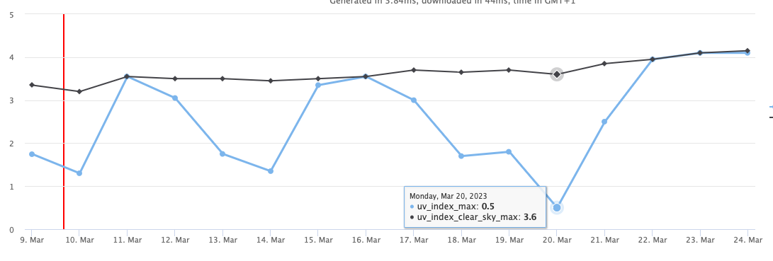
UV Index
The UV Index was also a frequently requested feature. Although the air quality API provided a UV Index, it was restricted to a five-day forecast and was not integrated into the standard weather forecast API, making it challenging to use. Fortunately, the UV Index is now accessible in the primary weather API.
UV index is based on GFS with updates every six hours. Ultraviolet radiation is absorbed differently by gases such as ozone, and weather models must explicitly calculate it. Other weather models from national weather services do not include ultraviolet radiation in their open-data program.
To integrate the UV Index, please adhere to the official guidelines provided by the World Health Organization regarding its presentation to users. The UV Index should be presented as a daily maximum value, although it may also be available as an hourly forecast.
Moreover, the "clear sky" UV Index is also provided, assuming no clouds. If clouds are inaccurately forecasted, the clear sky UV Index displays the maximum attainable UV Index.
Extended 16 day weather forecast
The weather forecast API now provides up to 16 days of weather forecasts. Although the accuracy of the forecast diminishes considerably after seven days, numerous weather models offer more than just a seven-day forecast. While I would not rely entirely on these extended forecasts, they could provide some insight into how the weather may evolve.
In the future, the 16-day weather forecast will be coupled with ensemble models to more accurately estimate the variability and uncertainty of the forecasts.
To enable the 16-day forecast in the Weather Forecast API, simply set the "forecast days" to "16 days".


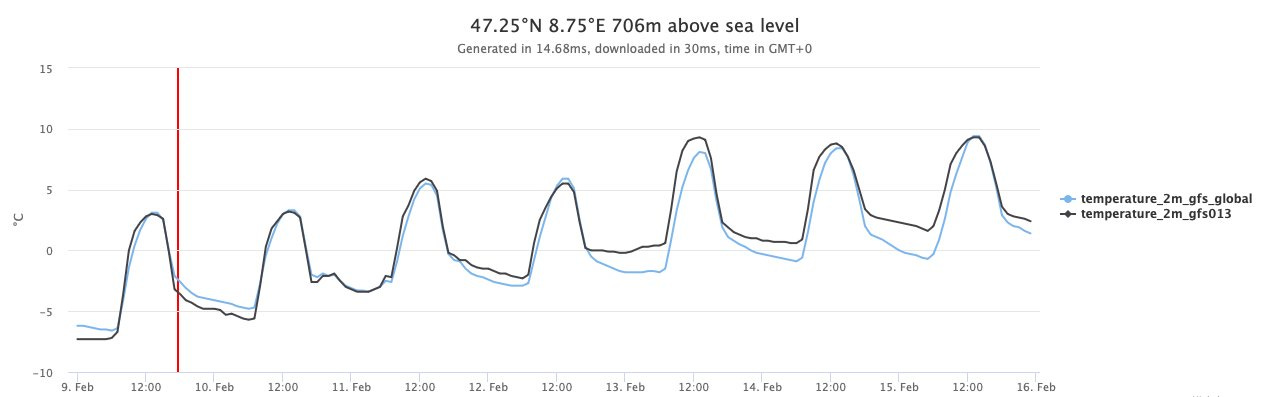
GFS upgrade to 13 km
As several of these features are now dependent on the GFS model, I have also transitioned to the 13 km resolution GFS model from the previous 25 km resolution. The finer resolution provides more accurate forecasts for regions with coastal and mountainous terrain. It also enhances the representation of local wind and temperature effects. However, in numerous other instances, the differences are barely noticeable.
Although the improved resolution is automatically applied to all APIs, it is important to note that the 13 km resolution is not available for all weather variables. Specifically, weather variables in the upper atmosphere continue to use the 25 km resolution, and the significance of the improved resolution gradually diminishes at higher altitudes.
For more information regarding the data source, please refer to the GFS API, which lists all utilized data sources.
GEM HRDPS Rotated Lat Lon Projection
As part of routine maintenance, the GEM HRDPS model has adopted the new rotated lat-lon projection, as the previous Stereographic Projection has been discontinued. The model still provides the same weather variables with a 2.5 km resolution.
Over the last decade, weather models have seen significant advancements, and the contributions made by national weather services are highly valued. With each update, forecast accuracy has improved. Weather models now incorporate a more comprehensive understanding of the physical mechanisms that drive weather, such as the interplay between the atmosphere, ocean, land surface, and biosphere. Thanks to the advancements in computing power and the ability to handle larger datasets, weather models can now achieve higher spatial resolution, enabling them to provide more precise forecasts for specific locations.

Outlook
In the coming weeks, several new features are in the pipeline. One of the upcoming features is the integration of weather data from 1940 onwards into the historical weather API using the latest release of ERA5 from the Copernicus program. Without revealing too much, I can say that amount of weather data at Open-Meteo will soon double :D.
To stay updated on the latest developments, be sure to sign up for our free newsletter.
Hi,
the UV index in the Forecast API is based on GFS, while the Air Quality UV index is using "CAMS global atmospheric composition forecasts". CAMS only offers 40 km resolution and 5 days forecast, therefor I am not using it in the regular Forecast API.
CAMS is however more precisely calculating the biologically effective UV radiation dose, while GFS is using a simplified approximation. Because GFS has a higher resolution, accuracy should still be comparable.
In my experiences the GFS based UV index seems to be slightly higher than CAMS. When comparing to other data sources, please make sure the index definition is the same. I noticed some APIs which use 1 as a base value, which could be misleading.
Hi and thanks for your great work. Is ti normal that the precipitation_probability_max returns null in the last 4 days using 14 days forecast? Check this
https://api.open-meteo.com/v1/forecast?latitude=42&longitude=-10&daily=weathercode,temperature_2m_max,temperature_2m_min,precipitation_probability_max,uv_index_max&timeformat=unixtime&timezone=Europe%2FBerlin¤t_weather=true&forecast_days=14