
Satellite Radiation API
Observed Solar Radiation from EUMETSAT and JMA Satellites

Tl;Dr: Solar Radiation data is now available in the Open-Meteo Satellite Radiation API!
Obtaining high-quality solar radiation measurements is challenging, as only a few stations provide highly accurate data. The best reference is the Baseline Surface Radiation Network (BSRN), but it consists of fewer than 50 stations worldwide.
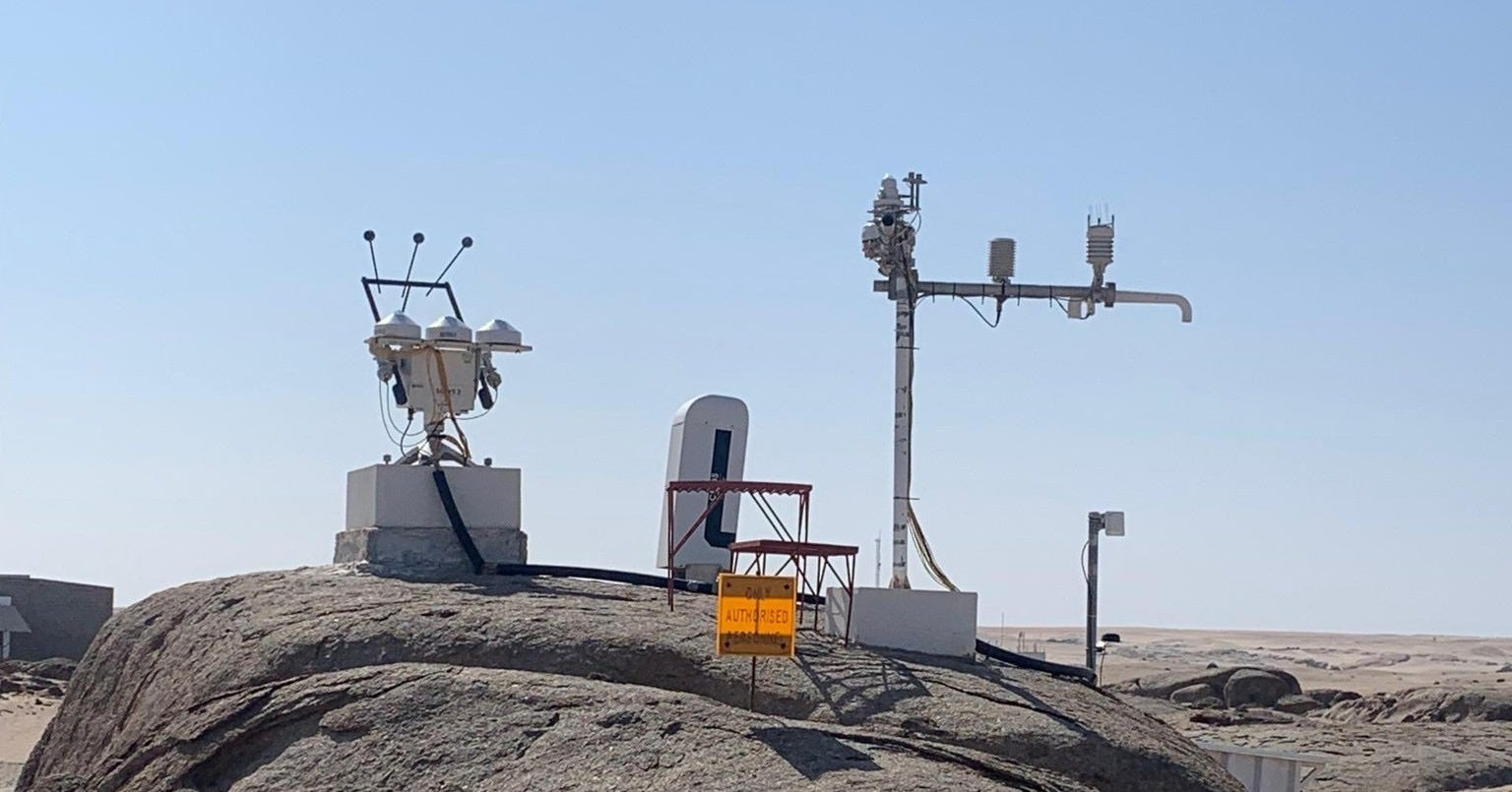
Obtaining precise solar radiation measurements is a significant undertaking. BSRN stations are costly and require careful maintenance. For example, the sensors must be cleaned every morning with a tissue that leaves no trace, as even the smallest residue can cause the optics to incorrectly measure the differences between direct and diffuse radiation.
Many applications, such as assessing the feasibility of new photovoltaic installations or estimating yield in operations, often occur in areas far from high-quality BSRN stations. Data from geostationary satellites can help bridge the gap between these high-quality local measurements and the global coverage needed in remote locations.
By using satellite sensors, direct and diffuse solar radiation can be estimated for any location. While additional data from weather models, such as aerosol thickness, ozone levels, humidity, temperature, and pressure, are required to improve the calculations, the resulting solar radiation data is generally of good quality.
Working with satellite data presents its own set of challenges, such as processing and storing vast amounts of data at high temporal and spatial resolutions. However, Open-Meteo specializes in handling large volumes of gridded data and providing a fast API, making satellite radiation data a perfect fit.
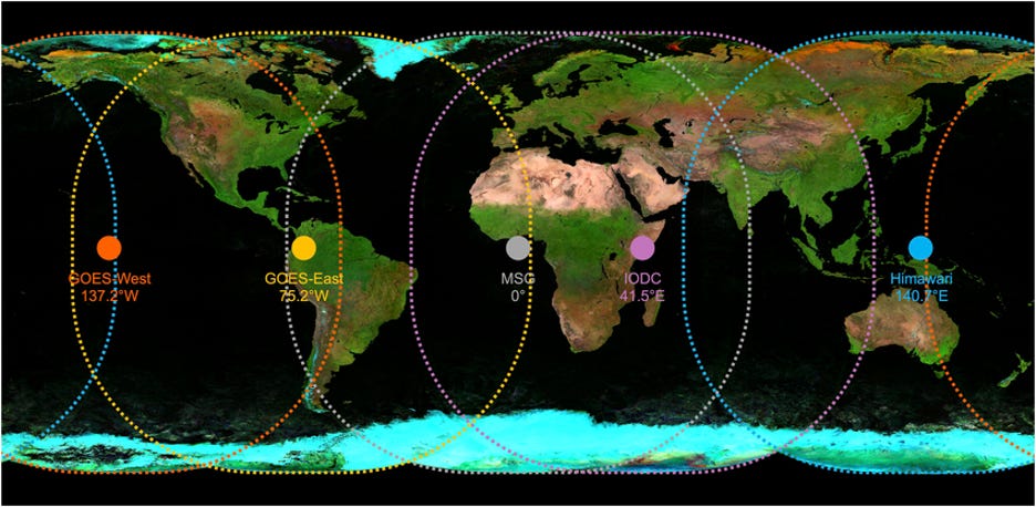
As a first step, four different satellite datasets have been integrated. Three of these use EUMETSAT data from the MSG and IODC satellites to cover South America, Europe, Africa, and parts of India. The fourth uses JMA Himawari satellite data to cover Asia, Australia, and New Zealand. Data from NASA’s GOES satellites for North and South America has not yet been integrated.
EUMETSAT LSA SAF
The EUMETSAT Land Surface Analysis project generates derived products from satellite data, including direct and diffuse solar radiation, surface temperature, vegetation indices, evapotranspiration, and wildfire monitoring.
Two solar radiation datasets are available based on the MSG and IODC satellites:
0.05° (4-5km) spatial resolution with 15-minutely values
Updated every hour with roughly 2 hours delay to real-time
EUMETSAT CM SAF SARAH3
Like LSA SAF, the CM SAF Surface Solar Radiation Data Set - Heliosat (SARAH-3) is based on MSG satellite data. However, SARAH-3 undergoes extensive validation and corrections to ensure top-tier data quality for Europe and Africa. With records dating back to 1983, it serves as an excellent resource for analyzing the long-term sustainability of photovoltaic installations.
0.05° spatial resolution with 30-minutely values
Updated daily with 2 days delay
Data from 1983 onwards
JMA JAXA Himawari
To extend coverage to Asia, Australia, and New Zealand, Open-Meteo has integrated data from JMA and JAXA, sourced from the Himawari-8 and Himawari-9 satellites. These datasets provide 10-minute interval data at a 0.05° resolution, with a minimal delay of just 20 minutes from real-time.
0.05° spatial resolution with 30-minutely values
Updated every 10 minutes with 20-minutes delay
Data from 2022 onwards, but archives from 2015 are currently being processed
NASA GOES
NASA GOES satellite data has not been integrated yet, so data for North America is currently unavailable. While we plan to add GOES data in the future, there is no estimated timeline at this time.
Scan-Timing, Gap-Filling and Temporal Averaging
Working with satellite data is more complex than it might seem, with several nuances that need careful handling.
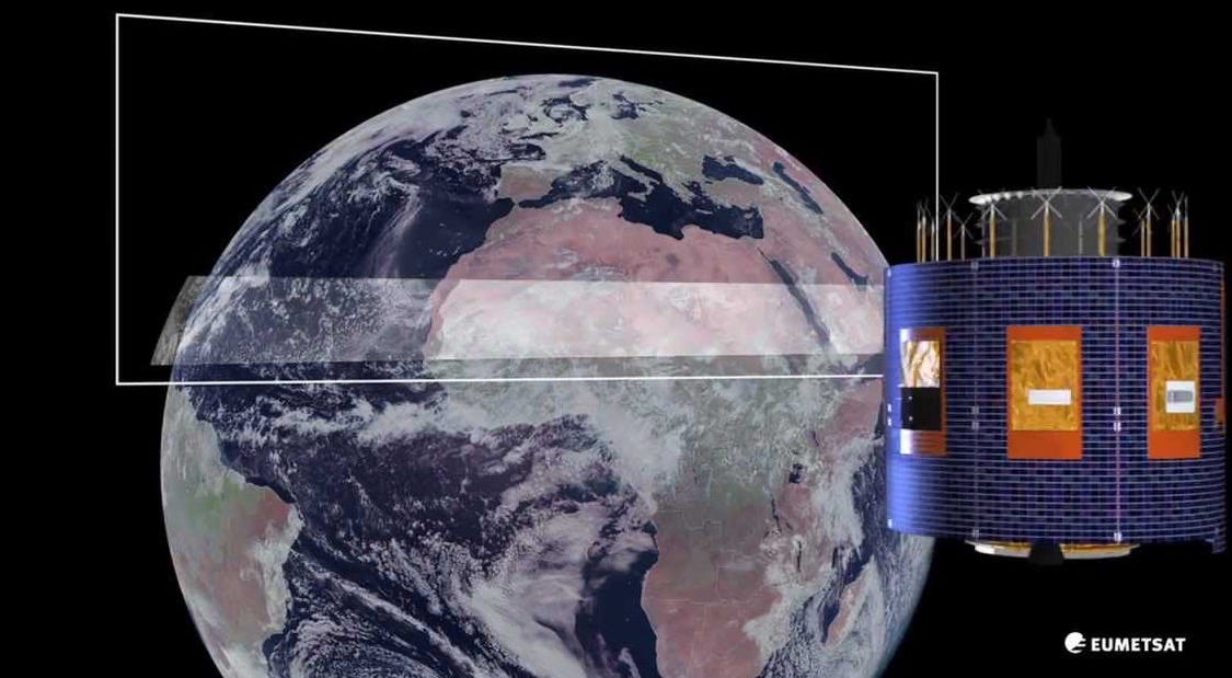
One key challenge is that while data is provided at 10, 15, or 30-minute intervals, these timestamps don’t represent exact moments in time. Satellites scan the Earth from north to south, and by the time the scan reaches the southern regions, an additional 10 to 15 minutes may have passed. Though this delay might seem minor, it can significantly impact the accuracy of solar radiation data.
To address this issue, Open-Meteo applies solar position algorithms to calculate 10, 15, or 30-minute averages. Averaging simplifies the handling of solar radiation data. For example, when comparing solar satellite data with weather model data—typically averaged over an hour—you can simply take six 10-minute intervals, average them, and make a direct comparison. Using instantaneous values wouldn’t be accurate, as they don’t account for changes in the solar position. While this may not be critical for all applications, ensuring proper data processing is key to maintaining accuracy.
Satellite data often contains missing time steps. For example, Himawari satellites skip two time steps daily due to housekeeping and maintenance. Smaller gaps, typically a few hours, are filled using interpolated data based on solar position algorithms to maintain consistency. However, some larger gaps spanning several days remain and cannot be corrected. Despite this, overall data coverage is still quite good.
API Integration
All data is now available through the Satellite Radiation API. The interface also enables direct comparisons between satellite data and weather models. While some weather models are highly accurate in solar radiation forecasting, others are less reliable for this purpose. Feel free to give it a try yourself!

The API returns per default aggregated data to 1-hourly values. If you want to get the original temporal resolution of 10, 15, or 30 minutely data, you have to select “Temporal Resolution“ to “Native”.
Outlook
Downloading, integrating, and ensuring timely updates for these four datasets took several months. Using this data, we aim to gain a better understanding of weather model accuracy and further improve solar radiation forecasts.
We also hope to support researchers by providing easy access to satellite radiation data, making their studies more efficient. Many scientific papers we reviewed mentioned that obtaining satellite data often took months, as it is typically challenging to work with.
As noted earlier, the integration of NASA GOES satellite data is still pending, and that will be a future task. Additionally, the archives for Himawari satellites from 2015 onwards are still being downloaded, which is expected to take another six months.
If you haven’t already, make sure to subscribe to the Open-Meteo blog!
Is Open-Meteo still active?